I would like to buy a map of Marathis’ Cradle please. Wait, this doesn’t look right. What do I mean “it doesn’t look right?”! The rainforest valley is clearly not that wide, ask anybody on the caldera’s west face!
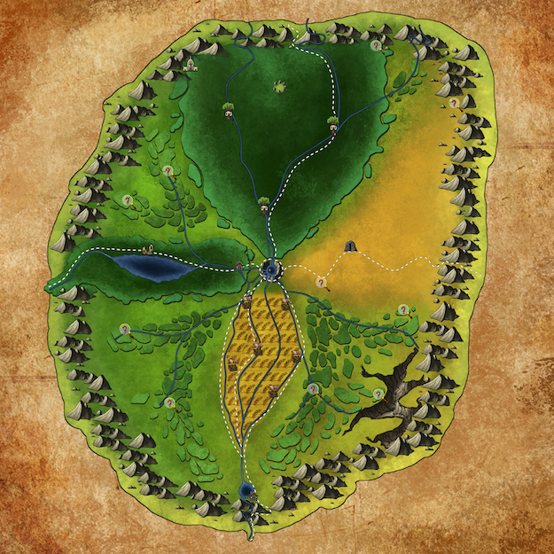
Hello, and welcome back to this special Groundbreaking. We have a map! At some point during the first few posts of Groundbreaking, I decided to sketch out a rough idea of what I was working with. I kept it simple, so that I wasn’t spending a lot of time on something I am horrible at (art) as well as not wanting to redraw it every other week after coming up with new ideas. When I posted about the scale of the region I decided to revisit my original drawing and bring it up to date with all of the descriptions that I had done thus far. Almost immediately, I wanted to get a real artist to create a real map for us to have, and so I started to set aside some funds as well as look for ideas.
Recently, while working on a side project, I decided to reach out to the artists and boy am I glad I did! I would like all of you to take a minute and thank Tony “MrKrane” Carter by visiting his portfolio at https://www.artstation.com/krane. Please get this guy some more work so he will cut me deals on future art! 😉
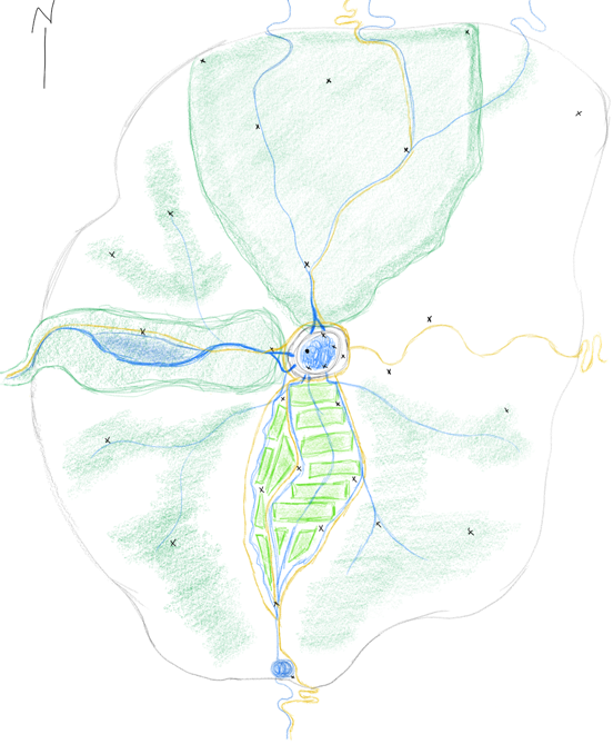 My original drawing was purposely not to scale, so that I could see the details, and some of that leaked into the drawing I cleaned up. While working on this piece, I had the caldera made smaller to give the region a much larger looking scale than in the original drawing I posted previously. Additionally, some of the items he placed differently than I had visualized in my head (and tried to convey in my writing) but I really liked the way he laid them out and so I kept them, such as the ravine. Until I was putting this piece together, I had completely overlooked that I had purposely skewed the scale of the ravine and rainforest and swamp to the west! I enjoyed his rendition of it so much that I completely forgot that I called out the average depth (400 ft.) and width (1 mile) … numbers that probably shouldn’t be more than a line on the map!
Luckily, Groundbreaking is a blog about World Building, with a Sandbox location as the focal point. We can change what we want, when we want! Let us take a look at the areas we are going to retrofit, the inconsistencies on the map, and the locations that have been marked.
Retrofit: Adding the south eastern gorge
The gorge to the south-east is based on my mention of multiple ravines in the desert. The gorge is wedged between the mountain border on the south and east, light tree covered hills on the west, and a sliver of connection to the desert itself. Both of the rivers in this region drain into the gorge, join together, and make their way south east and underground where their final destination is unknown. This gorge is the rumored home of the chimera that is known to hunt in the south-eastern reaches of the desert.
Retrofit: The western ravine and rainforest
The ravine to the west that houses the rainforest can be addressed in multiple ways. As a retrofit, we can simply say that the previous numbers were incorrect, and that it is much wider, thus bringing the scale of the map in line with our canon. As there wasn’t a lot of mention of the terrain above the ravine, we could simply say that the maps are drawn with an incorrect scale as to showcase the terrain that exists inside the ravine for the purpose of annotating locations. We haven’t included any scale markers with the map, so this is simple and plausible. Additionally, we could claim that the lands in the ravine include a lot of underground cavern structures, that make it much wider below than above. This could potentially leave the scale of the map intact, while simply needing a caveat that the rendering is of the below ground areas. I like and can use all three, so I wanted to leave them all here for you decide in your own games.
For canon, though, I am going to combine the three. I am going to widen the average width of the ravine to 20 miles (from 1 mile) and the depth to 750 ft (from 400 ft) with areas of cavern structures that are up to 5 miles deep in some locations. This gives an area that was originally just a footnote or anomaly enough room to house some truly interesting locations and encounters without needing very much change thus far. It also makes the map look relatively close in scale. By keeping the western most area (that which passes through the boundary mountain range) to the originally specification, we are able to keep much of the original description of the whistling winds and white water rapids and hunting locations in tact.

by Tony “MrKrane” Carter https://www.artstation.com/krane
Location Markers
Marked on the map, you will find the following:
- Treehouse: Represents a Hunting Lodge
- Druid Circle: Represents the fact that a druid circle is rumored to be somewhere in that region
- Cathedral: The rumored ancient cathedral from before the volcano
- Houses: Towns (Pond Pass in the south, Glintwood Clearing in the entrance to the western ravine)
- Market Stalls: Farmland Marketplaces
- Stone Door: Dwarven Keep
- Question Marks: Places noted by travelers and adventurers that have not been verified as meaningful to the creator of the map.
I hope you enjoyed this update, especially our new map! Please continue to join us at our Discord server https://discord.gg/Rt79BAj and let Krane#6373 know how you liked his map!